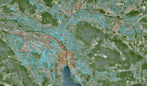
Fig.: Visualization of the MATSim model of Zurich.
The transportation and land use Module (WP5) work package consists of three main objectives: (a) research and development, (b) integration and (c) implementation of the transport and land use model in the two case studies of Zurich and London.
Research and development
The research part envisages both the issues of spatial regression and mass optimization. Spatial regressions are applied to build an economical predictive model of e.g. link speeds or link loadings. The availability of regression models especially allow improved monitoring of the transport network, optimizing system operations, and forecasting for navigation systems. In the proposed work, regression models additionally provide default values for visualization purposes (see below in the subsection implementation). The underlying data is either commonly available or extracted from adequate models. However, the availability of such models is normally restricted due to high cross-disciplinary requirements. The proposed new GIS-data-warehouse offers new possibilities to estimate spatial regression models due to the cross-disciplinary and interconnected models, i.e. urban and transport modelling, building models and urban development.
Mass optimization recently gained in importance due to limited land resources and the massive growth of urban systems and rural depopulation. Optimized urban and transport planning is an interdisciplinary field and requires adequate models. However, standards in urban design lack of a fundamental research base. The proposed new GIS/data-warehouse allows the development for new methods of mass optimization. Shape grammars are addressed for mass optimization due to their recent promising development and increasing number of applications in city modelling and planning. Shape grammars are procedural rules, which are applied in transport network design and building and urban planning. The major advantages of shape grammars are the simple and often universal application possibilities as well as very low computational requirements. Shape grammars are elaborated and evaluated for improved mass optimization, based on the interfering models of the considered disciplines. For this purpose, existing approaches for shape grammars evaluations are applied for evaluation purposes.
Integration
Transport and land use models of different sizes are potentially suitable for the envisaged implementation. Disaggregated model encompass high spatial resolution and many parameter values, but are often restricted due to long computational time and sensitive data requirements. The proposed method integrates different spatial resolutions to reduce computational requirements. Concurrently, sensitive data requirements are kept on a low level.
Therefore, a large scale transport and land use model is proposed for application lower level of details. This large scale model accounts for relevant spatial influence due to migration, de-/population and corresponding land use changes. The lower resolution of the transport and land use model is on a municipal level, or city quarters if necessary. This resolution level facilitates the later transfer to business applications. Sensitive data requirements are kept on a low level due to the low resolution. The currently established model of the project of SustainCity or the new land use model of Switzerland are applicable. Both models highly interfere with the transportation side. State-of-the-art models of science come into practice.
The disaggregate level includes detailed methods of urban planning and takes place within municipalities or city quarters. The core elements of the disaggregate level are shape grammars (see above for more details). If necessary, shape grammars are supplemented with current transport network and urban design methods. Data of migration, land prices and usages etc. are integrated from the upper level described above. The advantages of a two level approach are the novel complement of major planning approaches accounting for their strengths, a minimal dependency on sensitive data due to aggregated data in the upper level, the major reduction in calculation time, and the preservation of plausibility. Shape grammars can be used in an interactive platform, similar to recent software products like CityEngine (Procedural).
Climate specific data extraction has to be developed specifically for the envisaged project. The default data extraction addresses energy consumption, heat and CO2 production. Energy consumptions for buildings and transport are subdivided in embodied and consumer energy consumption, extracted from aggregated transport and building model data, and based on available models for household investments, fuel prices, car fleets, etc.
Implementation
The highly adaptive software tools for transport and land use models are supplemented with the interface to the data warehouse. The interface transfers model results to the warehouse, and, vice versa, operates the transport and land use models. Therefore, data exchange can be guaranteed between the modules. For the case studies, the existing transport and land use models are transferred to the data warehouse and cloud servers. The warehouse is supplemented with the necessary data for the case studies and linked with the software, depending on the cloud system. The results of existing spatial regression models and the results of DES-T5.1 are implemented as default values in the data warehouse.
