
Rome – Adriatic
Crossing Italian territory along Via Salaria, 2010
When starting to investigate space complementary to cities and metropolises, we encounter and array of overlapping terms: land, territory, landscape; each term having different cultural and intellectual traditions. There seem to be in fact as many definitions of ‘territory’ as there are disciplines associated with it: from agriculture to economy and urban development, and from geology, hydrology and ecology, to juridical realm and geo-politics.
Clearly, old dichotomies in approaching the notion of territory such as rural/urban and natural/artificial have, in European context at least, lost most of their meaning. As an alternative, in this research we sketched out a new set of conceptual tools. Firstly, we spoke of continuity - of a territory being urbanized in its entirety – knowing that it is not a compact urban form that makes a city, but rather the ways the ways in which a territory is occupied and used. The second characteristic we tied to the notion of territory was dynamism; its continuous remodelling through both natural and human factors, inextricably tied together. Seen in this way, a territory is a physical space as much as it is a mental construct; a territory is, in the words of Andre Corboz, a palimpsest: a form, a product, and a project simultaneously. Finally, we also understood territory as a system evolving over time. In the process, physical territorial structures such as circulation networks or property boundaries are not only evolving physical shapes and forms; rather, they become primary instruments of organization of society – of its power relations - in a given historical period.
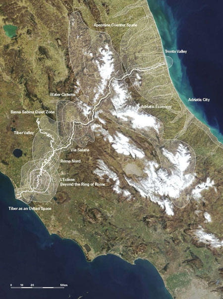
Via Salaria has lent the research an element of coherence. Salaria, our primary research device, is the first Roman consular road and one of the oldest territorial elements in the Apennine peninsula between Rome and Ascoli. Through the strategy of the section – cutting through the Appenines along Via Salaria - we have conceived twelve distinct territories, each with their own transformation dynamics. They range from the dense coastal metropolitan areas, to the peri-urban and agrarian zones belonging to the Apennine mid-range and to the scarcely populated mountain areas.
At first glance, this section is characterized by symmetry. But in fact the Northern and the Southern slopes of the Apennines, the Tyrrhenian and the Adriatic, are very different, specific landscapes. Not only are their natural conditions entirely different, even historically the two sides have developed relatively independently. On the Tyrrhenian side, urbanization takes form based on old gravity centers, Rome and Napels; on the Adriatic side, the recent metropolization spreads linearly along infrastructure, without connection to historical urban forms - or even to planning. The Apennine range, it seems, does present an obstacle between the Tyrrhenian and the Adriatic space. The strong movement lines follow the North-South axes, while the weak ones, such as Via Salaria, follow the East-West sections.
In part, we looked for dependencies: we wondered where are resources located and how are they distributed; what are the centers and what are peripheries; how far is the reach of Rome? With astonishment we have encountered dependences between natural and anthropogenic elements in the territory: in Rieti and Rome for example, water is directly linked to politics; at the Adriatic sea urban growth has meant severe coastal erosion. We were less surprised to observe the influence of Rome in transforming former rural areas into peri-urban and suburban settlements, dependent on public transport.
But most importantly, what we have looked for in this research were the active energies of transformation in the territory. Both urbanization and globalization are processes whose impacts, sometimes overlapping, we were able to detect. Different segments of territory seem to be linked to global economic cycle, irrespective of their remoteness. Settlements in Apennine nature parks for example, are exposed to dual dynamics: on the one hand, they experience a long-term trend of depopulation, on the other a development of food and tourist industries, apt for global market. The global impacts are both obscured by and propelled by structures that are carriers of local identities, such as the built structure, land use, local craft traditions, cultural and natural heritage, etc. In short, globalization is not transparent, and it is hardly obvious; its face is less generic, and more local, non-conflicting, recognizable.
The topics are:
Via Salaria - Circulation networks
Making of the Landscape - Tronto valley
Making of the Landscape - Tiber basin
The Apennine Counter Space
The Apennine Water Cisterns
Bassa Sabina Quiet Zone
Rieti - provincial capital
Adriatic City
Adriatic Economy
L’Eclisse: Beyond the Ring of Rome
Roma Nord
Tiber as Urban Space