
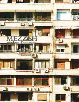
Mezzeh
modern Damascus
Students: Elsa Wifstrand, Rujun Jia
Location: Damascus
Date: October, 2009
Type: Research project, student work
Background
During the Cold War, the Middle East was a theater of ideological struggle between the two superpowers: the United States and the Soviet Union, as they competed to influence regional allies. Whereas Israel, from early on, sided with the US, many of the Middle Eastern countries were either close to, or directly supported the then Soviet empire. In November 1956 Syria signed a pact with the Soviet Union, providing a foothold for Communist influence within the government in exchange for planes, tanks, and other military equipment being sent to Syria. But the relationship to the Soviet Union of course went further than just touching upon military aspects. It also included the exchange of students, researchers and other people from an academic field, as well as traders and their middlemen, i.e. an intense cultural exchange. Today, the focus on Russia has weakened considerably with Syria opening up to a globalized economy and trying to attract other types of investors, partially from the Gulf region. Nevertheless, the exchange with the Soviets has left a lasting imprint on the city, also on the level of its architecture and urban development.
Themes
When entering the city of Damascus via the Faiz Mansour Street, also called ‘Mazzeh Highway’, one is faced with imposing residential housing blocks dating back to the 1960s. Oriented at an angle to the direction of the street, the buildings, constructed out of prefabricated concrete elements, guide the traveler into the city. They are just one of the many neighborhoods that were developed during an era characterized by Soviet influence.
Project
What is the urban idea of the ‘Soviet City’? Does this type of urban morphology represent an ‘international style’ applied to many parts of the world? Is it linked to an ideology of communism or cold war politics? How are these buildings and the urban fabric perceived today in Damascus? How do the buildings adapt themselves to lifestyles and demographic structures of the Damascene population? What is their perception today? What is the relationship between the French mandate planning which introduced the concept of infrastructure axes and traffic flow, and the planning period of the 60s and 70s? Is the latter just the continuation of the former? Sketch out a possible future for these areas and their buildings. How does this architecture compare to the urbanism and architectural production of the same era in Beirut?
Download the Book PDF